Wolf Risk Maps
Click here view Interactive Risk Map
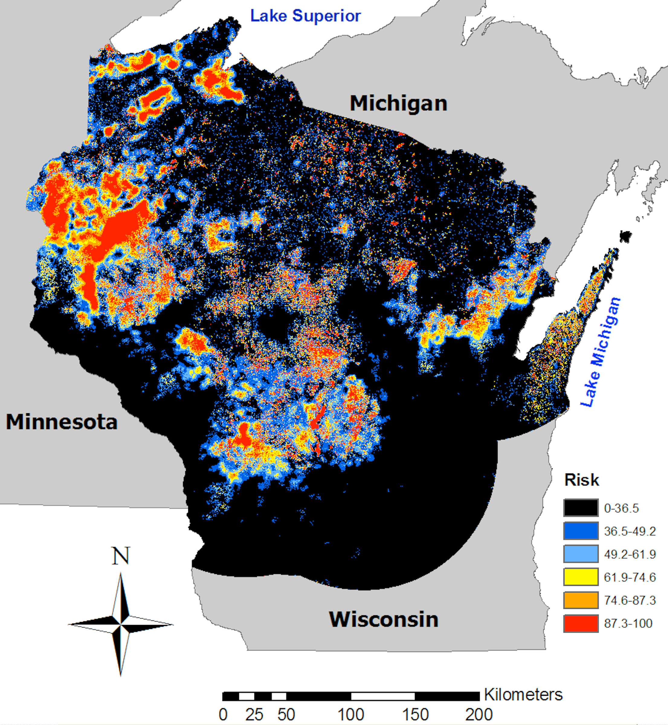
Estimated risk of wolf attack on livestock within 100 km of any Wisconsin wolf pack known in the winter of 2009. The model is 91% correct in predicting wolf attacks from 2007-2011 and is expected to be that correct in the future. Black areas represent the lowest risk category where livestock are predicted to be unaffected (but keep in mind the 9% error rate of the model). Other colors represent even distributions of risk from blue (low risk) to red (highest-risk) where 43% of future wolf attacks on livestock fell in red areas (6.2% of the map). Risk was not estimated for gray areas. Risk is estimated from distance to the nearest wolf pack, distance to forest, and percent area under grass, hay, or pasture, as explained in Treves, A., Martin, K.A., Wydeven A.P., Wiedenhoeft, J.E. (2011) Forecasting Environmental Hazards and the Application of Risk Maps to Predator Attacks on Livestock. Bioscience 61:451-458.
Risk Map Applications for Carnivore Conservation
Environmental hazards, such as emerging diseases and wildlife damage, are distributed in non-random patterns. Therefore, many biologists work to predict future locations from the past patterns of environmental hazards. Risk maps can help predict where hazards will occur, whether they concern invasive species, emerging diseases, or predator-prey ecology. Thus risk maps promise early warning and a way to target preventive action, which can safeguard both humans and ecosystems. Such prevention is particularly important when humans react to hazards by destroying the environment or retaliating against species, as is seen in conflicts between people and predators. Over the past two centuries, people have eradicated numerous populations of predators, including two species driven to extinction. Preventing conflicts between people and predators at the outset would support worldwide efforts to conserve biodiversity and to restore ecosystems. Prevention of conflicts with predators would also protect human life and livelihood.
Forecasting Environmental Hazards and the Application of Risk Maps to Predator Attacks on Livestock
We have pioneered the development of risk maps for predator attack on domestic animals. Foremost, we verified our models' predictions on "future" data that were not used in model construction: We constructed a model for gray wolf attacks on livestock that took place from 1999 to 2006 in Wisconsin, and its predictions were verified by the data from subsequent affected sites from 2007 to 2011 with 91% accuracy. We also showed that 43% of "future" sites fell in the highest-risk areas (red areas in Figure 1), which represent only 6.2% of the area analyzed. We constructed a model for wolf attacks on bear-hunting dogs in Wisconsin using similar methods.
Preventive intervention can be more focused and cost effective when high-risk clusters are targeted than when risk is assumed to be ubiquitous. First, private citizens may be able to modify activities, animal husbandry, or habitats to reduce their vulnerability with a diverse array of antipredator deterrents. Second, managers can work proactively with residents on cost-effective preventions in areas where conflicts are most likely. Third, policymakers may use risk maps to promote selective treatment of both problem predators and problem properties.
Please visit our Publications webpage to see scientific articles that describe wolf depredation, interventions to mitigate human-wildlife conflicts, and the human dimensions of these conflicts.
Environmental hazards are distributed in nonrandom patterns; therefore, many biologists work to predict future hazard locations from the locations of past incidents. Predictive spatial models, or risk maps, promise early warning and targeted prevention of nonnative species invasion, disease spread, or wildlife damage. The prevention of hazards safeguards both humans and native biodiversity, especially in the case of conflicts with top predators. Top predators play essential ecological roles and maintain biodiversity, but they can also threaten human life and livelihood, which leads people to eradicate predator populations. In the present article, we present a risk map for gray wolf (Canis lupus) attacks on livestock in Wisconsin between 1999 and 2006 that correctly identified risk in 88% of subsequent attack sites from 2007 to 2009. More-open habitats farther from any forest and closer to wolf pack ranges were the riskiest for livestock. Prediction promotes prevention. We recommend that the next generation of risk mappers employ several criteria for model selection, validate model predictions against data not used in model construction before publication, and integrate predictors from organismal biology alongside human and environmental predictors.