Wisconsin Buffer Initiative

Ventura/Vander Zanden Research Team
"Where are buffers most needed across the diverse land use types and landscapes of Wisconsin?"
The team's involvement with the WBI was to examine the role of buffer strips from an "in-stream perspective", focusing on the sensitivity of aquatic systems to land use and perturbations. This approach complements the land-based perspective being pursued by other participants of the WBI. This component involves a GIS-based approach and relies on available databases and GIS layers for the state of Wisconsin. (DNR fish database, DNR stream classification database, USGS Aquatic GAP database, National Heritage database, USGS stream data, EPA reach files, soils, geology, etc).
Specifically, these research groups completed an extensive review of the literature pertaining to stream classification, obtained relevant data sets, and prepared them for inclusion in a GIS-based analysis of Wisconsin streams and landscapes.
The research team adopted an Analytical Hierarchy Process (AHP) to complete their research.
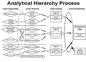
The AHP framework developed for the WBI contains four analytical layers:
- Level 1: Input Data Sets- weights are assigned according to a feature's importance within this data set.
- Level 2: Land/Aquatic Factors- comprised of input data sets that are assigned weights based on a data set's importance relative to other data sets.
- Level 3: Management goals- comprised of multiple factors that are combined to address specific management goals and are assigned weights based on a factor's importance relative to other factors.
- Level 4: Composite classification- The final product resulting from the combination of weighted management goals.
The management goals included in Level 3 are intended to reflect the priorities of the WBI Advisory Committee and may continue to evolve. As a starting point, the research team identified three management goals:
- Management Goal #1: Buffers will be implemented to protect healthy aquatic ecosystems in each Wisconsin ecoregion.
- Management Goal #2: Buffers will be implemented to improve water quality by reducing the amount of excessive sediment, nitrogen, and phosphorus delivered to streams.
- Management Goal #3: Buffers will be implemented to sustain fisheries and recreation in Wisconsin lakes.
This research will help determine the design and prioritize the implementation of riparian buffers based on two characteristics of aquatic ecosystems: sensitivity to perturbation and responsiveness to intervention.
Sensitivity
Aspects of stream sensitivity can be divided into two categories, environmental setting and biological community. For a given degree of perturbation (broadly; land-use change), streams respond differently based on such watershed-scale factors as soils, geology, gradient, groundwater interaction, and vegetation. To assess sensitivity, the team looked at the effect of varying levels of perturbation on stream ecosystems across a range of environmental settings. These variables cannot be measured directly, so the team used surrogate parameters to represent them. Perturbation can be estimated by land use data. Stream response was characterized by water quality, physical habitat and biological community information. Some biological communities are more sensitive than others to changes in environmental conditions, or contain rare or endangered species. The presence of particular species was observed directly or predicted through habitat suitability models. Sensitive communities were identified by their narrow environmental tolerances. These factors were taken into account in addition to the environmental setting in determining overall sensitivity.
Responsiveness
For many of the same reasons that some streams are more sensitive to perturbation, some streams are more amenable to protection by buffers. Choices in the design of buffers, mainly regarding width and vegetation type, vary with the many of the watershed-scale factors listed above. Previous experiments have measured the chemical, physical and biological responses of streams to buffer implementation. Our work identified the types of streams where buffers have been most successful in order to prioritize future implementation.
Conclusion
Together the Ventura and Vander Zanden research teams worked to address two different, but related questions:
"Where is intervention most needed and where will buffers be the best intervention?"
The team is currently working on interactive mapping tools to display results of the watershed scale analysis (interactive map). The team is also working on a gis version of the "Universal Soil Loss Equation" (USLE) for the detection of areas with high erosion potential within watersheds.