Wisconsin Buffer Initiative

Norman Research Team
The overall objective for this leg of the WBI is to create a practical tool for field practitioners to use as a guide for designing effective buffers on typical agricultural landscapes. Specific objectives include the following:
- Establish field sites and measurement protocols to quantify the loss of sediment and phosphorus from several typical agricultural sites.
- Select or adapt a suitable model to generalize the results from the limited number of measurement sites to the diverse landscapes typical of Wisconsin.
- Use the combined results from the model and measurements to create or parameterize a practical tool for practitioners to use to guide the implementation of buffers in Wisconsin.
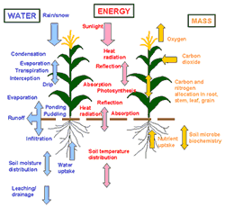 The research team is working to design a Decision Support System (DSS) for agricultural managers that combines what scientists know about the physical behavior of the agricultural landscape with the effects of management available to growers. The end result is a software package called the Precision Agricultural-Landscape Modeling System (PALMS). PALMS is a combination of several models that simulate the flow of energy, water, and some chemicals in the air-plant-soil system.
The team will adapt PALMS for use with buffers. PALMS is a processed-based model that currently computes runoff as a function of slope, precipitation intensity, heterogeneous soils, crop type, tillage type and orientation relative to the slope/aspect, residue and fertilization. The research group is working to add erosion and phosphorus chemistry to PALMS. The influence of buffers on plant growth and yield is calculated in PALMS for both the crop and the buffer vegetation as a function of location in the field.
Data to create this application tool will come from a combination of field measurements and output generated from PALMS over diverse scenarios typical of Wisconsin agriculture.